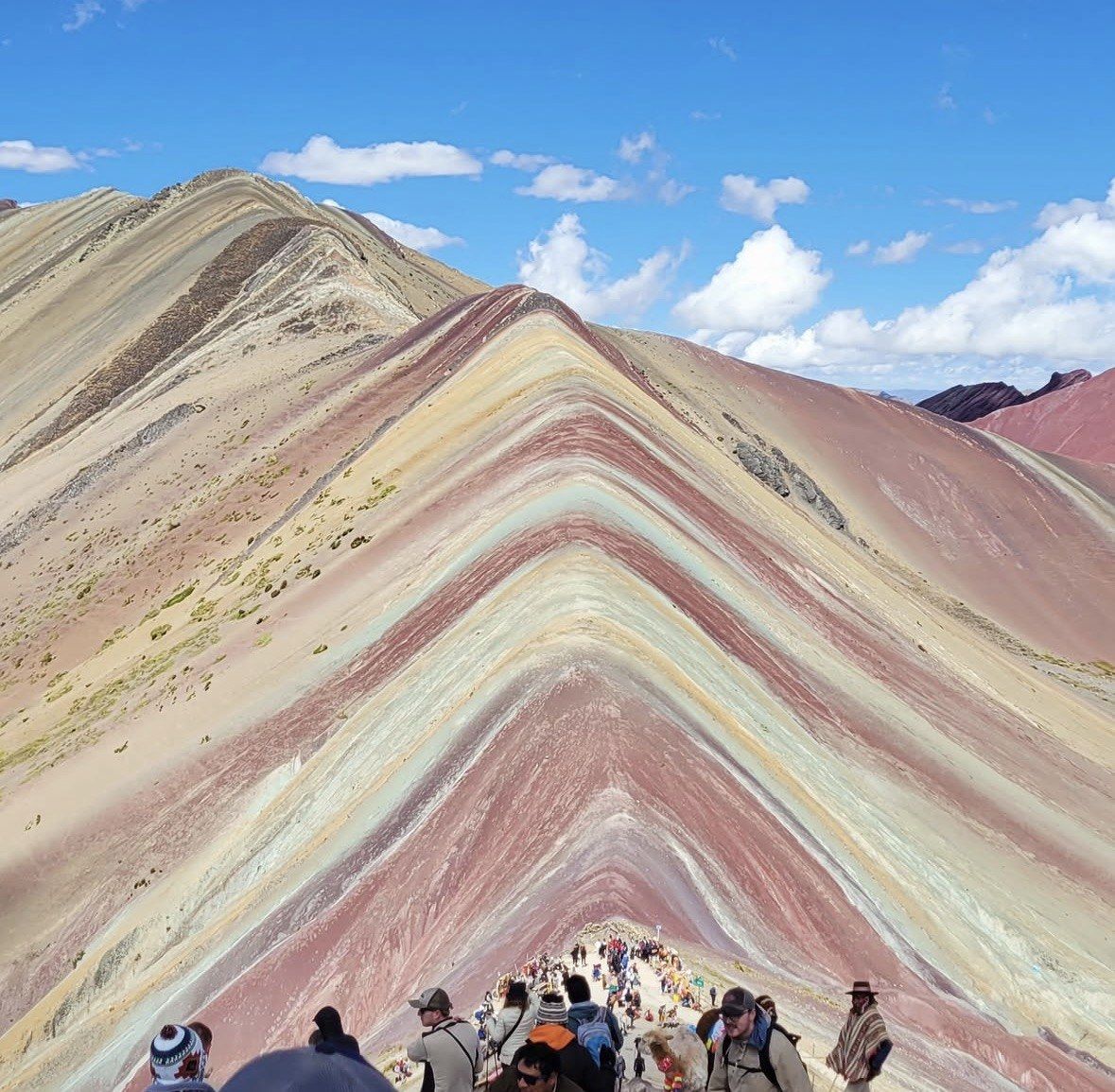
In shortRainbow Mountain is colorful because every band is a different sediment layer with a different mineral content: iron-bearing claystone for the reds, sulphur-rich calcareous sandstone for the mustard yellows, ferromagnesian phyllites for the greens, calcium-carbonate sandstone and marl for the whites. Tectonic uplift tilted those layers, oxidation and erosion exposed them, and the glacier cover that hid them melted in 2013.
5,036 m (16,522 ft)catalogued viewpoint altitude
About 2 million yearsage of the sediments
2013glacier cover gone
5 to 10 amstrongest colour window
Why Rainbow Mountain Peru is colorful
Water once covered this part of the southern Andes, and it dropped sediment in flat sheets: marine, lake and river material from the Tertiary and Quaternary, roughly two million years old. Every sheet carried a different mix of minerals, depending on what was being washed in and what the water was doing at the time. Stacked up, those sheets are the bands you photograph from the ridge.
Then the ground moved. Movement of the area's tectonic plates lifted the whole sediment pile into mountains, which is why the viewpoint now stands at a catalogued 5,036 m (16,522 ft) inside the Ausangate massif of the Vilcanota range. The lifting also tilted the beds, so the ridge crest cuts across them instead of running along one single surface, and you get stripes instead of a plain brown hillside.
The last two steps are chemistry and weather. Mineral oxidation driven by humidity brought the colours up, and erosion stripped away the material lying over the top. What is left on the Vinicunca ridge is a cross-section through two million years of sediment, standing in the open at over 5,000 m.
Rainbow Mountain mineral layers, band by band
Each colour family has a named culprit, and once you know which is which you can read the ridge from the viewpoint instead of just looking at it. The reds are the easiest: iron in claystone and clay of Upper Tertiary age, oxidised. The mustard-yellow band is the sulphur one. The green stripe fools almost everyone, because at this altitude nothing of that colour is growing.
The table below sets out the whole palette as the geological descriptions give it.
| Band colour | Rock and mineral behind it |
|---|
| Red | Iron-bearing claystones and clays of Upper Tertiary age |
|---|
| Mustard yellow | Calcareous sandstones rich in sulphur minerals |
|---|
| Green | Phyllites and clays whose ferromagnesian minerals colour the rock |
|---|
| Pink and fuchsia | Red clay, mud and sand |
|---|
| White and cream | Quartzose material, sandstone and marls rich in calcium carbonate |
|---|
| Earthy brown | Quaternary fanglomerate containing magnesium-bearing rock |
|---|
See the bands explained on the ridge
A 12-hour full day from Cusco from $22, rated 4.9 ★ (4062 reviews), with hotel pickup, breakfast and lunch, walking sticks and oxygen assistance, and a professional guide who can point out which layer is which at the viewpoint; the Vinicunca and Red Valley entrances are not included.
★ 4.9/5 · 4,062 reviews
The ice melted and the stripes appeared
For a long time there was nothing here to look at. Glacier caps sat over the mountain and the coloured strata stayed underneath, out of sight from the valley and from the Cusco agencies. The ice melted away by around 2013, mass tourism followed in the mid-2010s, and the communities on both sides of the ridge went from farming slopes to running an access point within a few years.
The scale of what arrived is worth holding in mind while you stand at the viewpoint. In the Cusco region only Machu Picchu draws more people than this ridge does, and the May to October high season puts as many as 1,500 pairs of boots a day on the slope you came to photograph, against around 600 a day once the rain sets in. Peru's state news agency has reported days of up to 2,000 since the site opened to tourism.
Nothing on the ridge is fenced off from that traffic, and the strata are soft material: clays, marls, sandstones. Keep to the marked path, which is what the communities ask of every visitor who comes through the control point.
The 2018 mining concession and the conservation area
In March 2018 a metallic mining concession of about 400 hectares, covering the whole mountain, was granted. Protests followed, the company renounced the concession in May of the same year, and a 12-month mining moratorium was put in place. By 2019 the coloured slopes sat inside a new protected unit, the Ausangate Regional Conservation Area.
That sequence explains the tone you meet on the ground. Access is controlled by the peasant communities of Chillihuani on the Cusipata side, in Quispicanchi province, and Pampachiri on the Pitumarca side, in Canchis, with community members working as guides and muleteers; the mountain straddles both districts and both provinces. There is no official visitor centre and no published telephone number for the site. The on-site conduct asked of visitors is short and specific:
- Keep to the marked trail rather than cutting across the coloured slopes
- The apachetas, the stone cairns built along the route, are sacred: do not add stones to them or pull them apart
- Whatever you carry up the hill, including wrappers and bottles, goes back down in your pack
- No drone flying without a permit
- Do not lean over edges for photographs
What makes the bands look strong or weak on the day you go
Time of day does most of the work. Low sun between 5 and 10 in the morning is when the oxidised layers read at their strongest, and that window is the reason tours pull out of Cusco hotels in the small hours. The viewpoints fill up between 9:30 am and midday as the city buses converge, so aim to be on the ridge before that.
Season decides whether there is anything to see at all. Peru's state news agency names May to October as the best window, with November to April bringing rain and snow that can cover the bands and slow road travel; operators stretch the dry window to April to October and call May through September ideal. February 2026 showed the other end of it, when heavy rain and snowfall damaged access bridges and a temporary suspension went under evaluation. Access status is reported by the communities and the municipalities rather than a single official page, so check on the day.
Weather on the ridge is its own factor: thin air, hard sun and temperatures that can drop sharply, in every month of the year. Snow lying on the slopes mutes the bands even when the sky clears. The weather page and the best time to visit page on this site go through the month-by-month numbers if you are still choosing a date.
Questions people ask
Is the green band on Rainbow Mountain vegetation?
No. The green stripes are phyllites and clays rich in ferromagnesian minerals, and the colour is in the rock itself. Nothing grows in sheets like that at this altitude, where the viewpoint is catalogued at 5,036 m (16,522 ft).
Are the colours of Vinicunca real or enhanced in photos?
They are real mineral colours produced by oxidation of the different sediment layers. How saturated they look depends on when you are there: between 5 and 10 in the morning they are at their strongest, and snow or rain between November and April can cover them entirely.
How old is the rock at Rainbow Mountain?
The coloured sediments date from the Tertiary and Quaternary, roughly two million years, and were laid down by water that once covered the area. For comparison, the jagged formation at Pallay Punchu is described as showing close to 250 million years of geological formation, a much older sequence.
Is Rainbow Mountain protected as a conservation area?
The striped slopes spent two months of 2018 under a metallic mining concession of about 400 hectares: granted that March, given up by the company in May after protests, then followed by a 12-month moratorium and, in 2019, by the creation of the Ausangate Regional Conservation Area. Day-to-day access is run by the Chillihuani and Pampachiri communities on the two sides of the ridge.
Why did nobody visit Rainbow Mountain before the 2010s?
The stripes were under glacier caps and simply were not visible. The ice melted by around 2013 and mass tourism arrived in the mid-2010s, which is why a mountain a little over 100 km from Cusco appears in no older guidebooks.
Read also